EnviroPress Reporter
Chirumhanzu district is located in the southern part of Zimbabwe in Midlands province and share borders with Kadoma on the north, Kwekwe on the west, Masvingo on the south, Gutu on the east, Shurugwi on the south, Gweru on the west and Chikomba on the north-east.
The district covers a total of 459 120 hectares. The district is under two traditional chiefs, Chief Chirumhanzu and Chief Hama. There are also 5 headmen that is, Mapiravana, Chaka, Bangure, Govere and Manhowo.
Minerals in Chirumhanzu
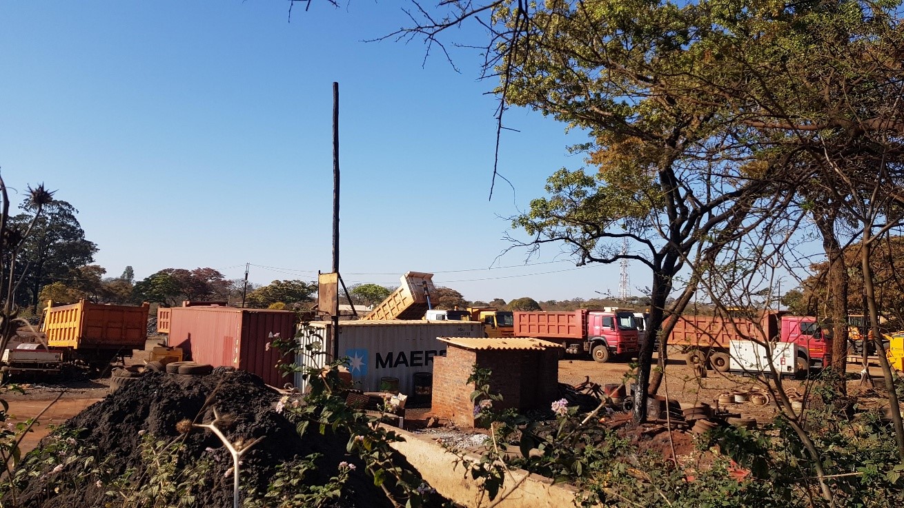
1. Chrome in Lalapanzi (pictured); exploited predominantly by Chinese companies and small scale miners.
2. Gold in Mvuma; was once exploited by a big mining company which has since closed down. Much of the mining being done by small scale miners, some of them unregistered/illegal.
3. Iron in Manhize; being exploited by the Chinese company TsingShan Holdings Group’s Dinson Iron and Steel.
Mining and conflict in Chirumhanzu
Runesu Ganha, an elderly resident of Mvuma, says dump-mining on the old Mvuma gold mine is growing and has been monopolized by a clique of politically-connected, powerful individuals who do not tolerate ordinary miners.
In Lalapanzi, a long time of chrome mining has failed to yield tangible returns for the community which remains dirty poor. Small scale miners complain that the big foreign miners are fixing the purchase price of chrome to keep them poor. Noise pollution, air and water pollution is rife, with mining activities in some previously undefiled areas driving wildlife especially hyenas into people’s homesteads.
In Manhize, many villagers who were displaced have never received any compensation to date while deep-seated dissatisfaction with the mining company’s alleged unfair labour practices have recently been reported by the media. There are serious disagreements between surrounding communities that each claim greater ownership of the land upon which the mineral is being extracted. There is also conflict between communities and the mining company regarding the benefits that communities feel they are entitled to enjoy from the mining activities.
Other resources
Chirumhanzu district has twenty-five (25) wards and of these 13 are communal wards and 8 wards are in the old resettlement area. There are 4 urban wards (wards 13, 14, 24) in Mvuma and 17 in Lalapanzi. These used to be mining towns.
Predominant tree species include the brachystagia species, combretum and acacia mixed in mostly savanna grassland landscape. Grazing areas are dominated by species such as eragrostis species, cynodon species, panicum species and setaria species, which are palatable for grazing animals.
In some areas unpalatable species like the hyperemia and the sporobolus species thus reducing available herbage in most grazing lands. Lantana camara has encroached into the grazing lands especially in wards 20, 22, 11 and 16 thus affecting the quality and quantum of grazing available.
Land degradation is a challenge in the district and the main causes include:
Overgrazing: Overgrazing is observed across the district. Formerly overgrazing was more pronounced in communal wards but has since spread across the district resulting in low carrying capacity of the veld in these wards.
Deforestation: Firewood is the main source of fuel for poor households in both rural and urban areas thus increasing deforestation. Tobacco production has also contributed to the high levels of deforestation in some wards such as wards 15, 19, 12 and 20.
Soil and water conservation: Farmers have not built contours and ridges due to a number of factors and this has resulted in a high rate of soil erosion and gully formation as well as siltation of water bodies. This has been observed especially in wards 2, 4 and 7.
Stream bank cultivation: A number of farmers particularly in the new resettlement areas cultivate near rivers and water ways with poor soil and water conservation practices which contributes to river and dam siltation. This is mainly as a result of ignorance by farmers as to the effects of their actions.
Most of the causes of land degradation can be eradicated through awareness campaigns and mitigation actions like planting of trees.
Chirumhanzu has 8 wards that fall in the Masvingo, Manicaland Middleveld Smallholder Livelihood Zone, about 5 wards in the Central and Northern Semi Intensive Zone and 8 wards falling in the Northern Cattle and Cereal Production Zone.
The main livelihood options are primarily agricultural based i.e. growing of crops and keeping livestock. Most crop production is rain fed which makes production very difficult due to the low and erratic rains. The Masvingo Manicaland Zone has better clay loam soils which in good years supports small grains production such as sorghum, millet, rapoko and ground nuts.
The bushy acacia species in the zone are ideal for goat production. However this is the most drought prone part of the district. The Central and Northern Semi Intensive Zone of the district has sandy loams which are prone to leaching and the low fertility challenge hence also often has low production.
The Northern Cattle and Cereal Production Zone is the bread basket of the district and is in natural region 3. It comprises mainly the resettlement part with the A1, A2 and old resettlement models.
There is significant cereal and livestock production by the resettled farmers and the cereals feed into the Chikomba, Gweru, and Mhondoro markets.
This project was made possible through a partnership with the Southern Africa Trust. The views expressed herein do not necessarily represent that of the Trust or its associates. www.southernafricatrust.org

